Verdun
Last month, on February 21, France officially commemorated the ninetieth anniversary of the battle of Verdun. The memory of the Great War is fading slowly in France as the country has literally a handful of living survivors from that conflict. Verdun, though, still has an important and distinct resonance in France considering the pomp and circumstance one noticed during the ceremonies—the President and the Minister of Defense both being prominent speakers.
Verdun is an ancient French city that reaches back to France’s Gallic roots. Located in the northeast, in Lorraine, Verdun sits at a crossroads of sorts. The swiftly-flowing Meuse River provides a north-south axis. To the West is gently rolling rich farmland that stretches nearly all the way to greater Paris. Only to the East is this broken up by a series of higher hills that formed an arc of protection for the city. Because of its location Verdun became an important French city during the Middle Ages and was the seat of an archbishopric. In the hundreds of years that followed other cities in the region superseded Verdun (Strasbourg, for example) and the city became a sleepy town of modest renown.
Verdun became important once again after France’s defeat in the Franco-Prussian War of 1870. France lost the provinces of Alsace and most of Lorraine to the newly-formed German Empire. Verdun was not lost: the city now was nearly on the new border with Germany. A worried French government began to fortify the surrounding hills to the east of Verdun with a number of earthenwork and reinforced concrete fortresses (a predecessor, really, to the more infamous Maginot Line) in the 1880s. These forts, Douaumont, Vaux, Souville, to name a few, became the new linchpin for France’s eastern defenses.
In 1914, at the start of the Great War, the Germans almost immediately began to attack the area. The fortresses proved their worth during the early stages of the war and the rebuffed Germans moved to the North and South of the city and took several miles of French territory. As a result, by 1915, one could describe Verdun’s place in the French line as a salient, or a bulge of sorts, that potentially could come under attack from at least two sides at once. The French clung to Verdun and its fortresses around it and the city started to empty of civilians by 1916 because of German bombardment.
Two years of fighting on the Western Front witnessed significant German advances: nearly all of Belgium and ten percent of France had been taken. On paper at this point the war certainly looked like a German victory. However, the war in the West had achieved a stasis and a blockaded Germany needed a quick victory for fear that it would be ground down by the Allies if the war continued too long. The German commander in the West, Field Marshall Erich von Falkenhayn, saw Verdun as a “breakthrough” chance for Germany. If Germany could focus enough of its forces on Verdun it could theoretically take the fortresses and the city, leaving the road to Paris generally open. That was Plan A. Plan B was literally to “bleed the French white.” Falkenhayn knew what Verdun represented to the French and that the French would defend it to the last. If he could not achieve breakthrough he would break the will of the French army instead. Of course, this would also mean the indiscriminate slaughter of German soldiers as well because of the difficulties of attacking against machine guns, barbed wire, and fortifications. But, c’est la vie…and c'est la guerre.
On the morning of February 21 the German assault came. In the first week alone the Germans fired more than two million artillery shells on some twenty-five miles of French defenses. In the first three weeks alone, at Verdun, more artillery shells were fired by the German army in this sector than during the entire American Civil War by both sides. One can describe the Great War as the first industrial war. The historian Jay Winter has likened this to a giant funnel where nations poured in materials, resources, labor, and humans into one end and out the other end, on the battlefield, the combined products of destruction emerged. The problem was that the enemy had a similar, and in France’s case, a larger German funnel pointing at them at Verdun.
The initial German assault, as a result of its ferocity, scale, and planning saw significant gains. It was the first significant movement on the Western Front since its initial attack two years earlier. In the first few weeks the French were thrown back, losing two of the fortresses in the network around Verdun: Vaux and the larger Douaumont. The German attack was unrelenting as Falkenhayn perceived the French were about to crack and he was not far from wrong. Morale, élan, and French fighting spirit sagged at Verdun as it seemed that the Germans would never stop. French officers as well threw their men, les poilu (the “hairy ones,” a French colloquial term for what we could call a G.I.) wastefully at the Germans and grumbling rose in the ranks. The weather was no friend to the poilus as well as late winter rains turned the zone into a muddy mess. By the late spring the French forces were ready to break.
The savior of Verdun was General Pétain. Pétain, of course, had greater infamy as the collaborationist leader of France during the Nazi occupation and Vichy era. France, as a result, has a difficult time dealing with his legacy (imagine the counterfactual of a Washington after the American Revolution later working with the British). Pétain realized that the French troops at the front at Verdun needed relief, supplies, and hope in order to last. He organized what was called the “Voie Sacré” or the “Holy Road.” This road, some forty miles in length was a non-stop highway of sorts that was solely dedicated to bringing in fresh troops and supplies to the beleaguered sector. This also allowed Pétain to rotate troops at the front lines much faster than before. The French slogan was “Ils ne passeront pas”—they shall not pass.
The German assault continued until June, gaining as many as twenty miles of territory in some sectors of the front. The French then began to counterattack. Falkenhayn had come close to bleeding the French white but he had also used a good deal of his reserve forces to do so. A British offensive on the Somme (equally as disastrous for the British) gave the French some relief. The French ground the Germans down mile by mile slowly recapturing lost ground. By October the French retook the Douaumont and by December the Germans were once again at their starting position, status quo ante, after ten months of battle. The butcher’s bill was horrendous. One hundred and seventy thousand French and one hundred and thirty thousand German soldiers died at Verdun. A good number more than that were wounded and mutilated, mostly from shell fragments. Up to this point this was indeed the largest battle in history and it “ended” in a bloody and brutal draw.
I had long wanted to visit Verdun because of its symbolism. Ironically, as a history professor I try to deromanticize the past to my classes but here I was on a pilgrimage that in some sense did the opposite of that. On Friday last week I took the train to Verdun for a week-end visit. I arrived in the mid afternoon and found a pleasant, quiet city of some fifty thousand along the banks of the Meuse. The western half of the city was on a bluff that overlooked the lower eastern side. Many of the buildings in town were of nineteenth century era and one could still see scattered evidence of damage from bombardment of nearly a hundred years past. It was too late to get to the battlefield area at that point so I waited until the next day to see it.
This trip was almost a whim as I had done little planning. Saturday morning I left my hotel asking the man at the desk about the battlefields. Tours often run to the battlefield but not during the winter (the town was a bit dead). I asked how I could get there and he suggested a taxi. While not wanting to be too cheap I did not like the idea of a taxi as there were several places I wanted to see and a taxi for that period of time would probably be too expensive. I thanked him and left. Nearby was the local tourist office (any French city of size has a nationally-run office of tourism) and I asked there as well about the battlefield and if I could walk there. Heads were shaken and frowns emitted. Well, one could walk there but it was so far…They did provide me with a pamphlet of the battlefields that had a map on it. Suddenly feeling perverse (perhaps my usual nature) I decided to walk there so I thanked them and left. And being the romantic, I wanted to feel, in the smallest and slightest way, what it might have been like for a soldier in 1916 to walk the last few miles of the Voie Sacre itself to the battlefield. Obviously, there is no way I could imagine what those feelings would have been like, to march off to a fifty-percent chance of being killed or wounded, but at least I could try to explain it to others.
Perhaps, this was not the smartest thing I had ever done. I had no idea of the real distance and whether the roads were walkable or not. The temperature was forty and the skies were on the verge of a mild drizzle. My map was about as detailed as a child’s adventure map on a McDonald’s placemat. The map did indicate a number of fortress and memorials but gave no idea of scale or distance. It did helpfully have three road numbers so I followed the first road out of town. Armed with an apple, a pocketful of almonds, my camera, an umbrella, and my fun map I was on my way.
Within a half hour I was out of the “suburbs” and I began to climb gentle hills to the north and east of the town. Well-tilled farmland was on either side of me as I walked on a two-lane country road that had about a six-inch berm for me to walk upon. Cars passed at the rate of one every ten minutes so most of the time I could easily walk on the asphalt itself as the side of the road was generally a bit muddy.
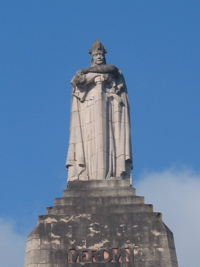
As I climbed the landscape began to change as the farmland ended and a forest began. It was also noticeably cooler and a few small patches of stubborn snow clung to small shady pockets. The drizzle stopped making it easier to walk as I no longer had to hold up my umbrella. I looked at my fun map for help but there was no real sign of how much farther I had to go. Perhaps this was not the best decision and I could see myself trying to flag down a car to ride back into town. However, within the next five minutes I came upon the first marker indicated on the map, a statue of Andre Maginot, the later Minister of War who fought at Verdun. This certainly relieved me and I began to walk more briskly to the next stop, Fort Souville, or what remained of what once was Fort Souville.
This fort exchanged hands a few times during the battle and as a result, little of it still remains save some underground bunkers and primitive pillboxes. What struck me most though about the area (and for much of the rest of my time on these hills) was the still pockmarked landscape. Artillery shell craters abounded, not yet swallowed up by nature. At one point ninety years ago nearly all of the trees and vegetation were gone and all that remained was a terrean moonscape. Now, the flora had come back but had grown over and around the destruction with a vengeance. In some areas the forests were incredibly thick, creating a dark, Tolkienesque undergrowth that I was glad I did not have to traverse.
No one else was there making the ruins of the fortress seem a bit eerie. The trail was muddy and I stuck to the side of the trail stepping on the drier dead leaves as I wandered the area. I poked around for twenty minutes and decided to leave as I did not know how much more I had yet to walk and it already was noon. I walked back down to the main road and continued, according to my now seemingly reliable fun map to the Douaumont.
By this point I saw one of the first road signs (with no kilometers listed, sadly) that pointed the way to the fort. Within a mile I crested another hill and came across a clump of buildings, the first I had seen since I had left the farmland below. Luckily, one of these buildings had a café and I took a quick lunch as I was very hungry—I washed it down with one of the best beers in my life at the restaurant, local Lorraine Trappist ale.
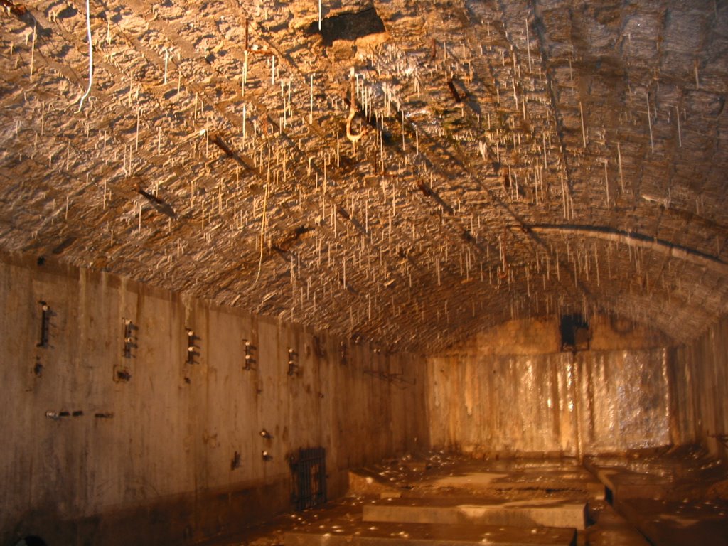
Fortified and restored, I made it to the Douaumont just as it started to rain again. The fortress did not disappoint. As a name in France, Douaumont has nearly as much resonance as, let us say, Pearl Harbor does in the US, even if it represents something different. My favorite French film, Jean Renoir’s “The Grand Illusion” has two scenes where fortress’s memory resides prominently. Of course, when I say fortress one might think of battlements and parapets but most of these fortresses were underground. Douaumont sat atop a hill at some 1400 feet, the tallest in the immediate area and had a fairly commanding view. The French dug down into the hilltop many feet producing a series of underground bunkers with communicating tunnels. Atop these were steel and reinforced concrete emplacements that held machine guns, artillery, and counter-weighted turrets of many tons that could be raised and lifted flush from the hillside to fire upon the enemy. In today’s money it would have been many millions of dollars to build such a complex. Two cars and four other tourists were there so I practically had this fort to myself as I wandered about.
The feeling was eerie to say the least as I walked down the corridors only hearing my footsteps and the constant drip-drip of water. Little stalactites, like delicate skeletal fingers, hung from the ceilings everywhere. The rooms were nearly countless: washrooms, a bakery, command post, sleeping quarters, kitchen, and so on. A touching memorial to some seventy German soldiers was in one room—they died simultaneously as a shell exploded in a room nearby. Much of the Douaumont is closed a result of many corridors being unsafe due to fear of collapse. After some forty minutes I realized I had to be on my way as I had one more stop to go and then still the walk back to Verdun.
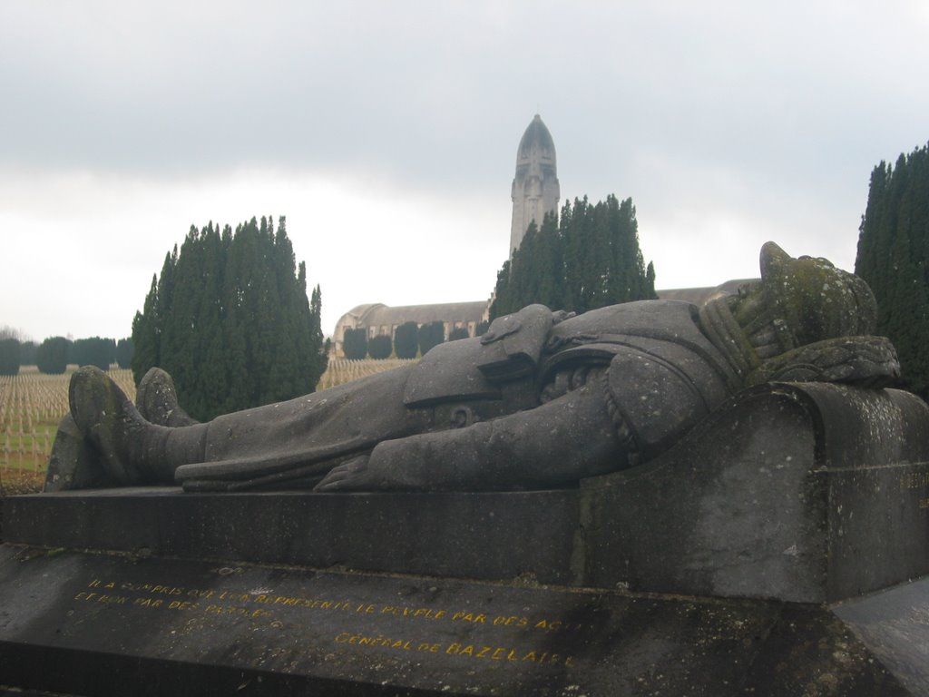
The Ossuary of Verdun is a fifteen minute walk from the Douaumont. It was the project of the Archbishop of Verdun after the Great War. He wished to recognize the fallen of both armies with a national cemetery. In 1919, workers went to the battlefield to recover as many bodies as they could—I can think of few tasks that would be more grisly. Over the next year the workers brought the remains of some 130,000 men, mostly unidentifiable, to the cemetery, where they were laid to rest. Some 10,000 crosses are at the Ossuary of the soldiers that could be identified at the battlefield. The Ossuary itself is a two-hundred foot tower that sits over a low building the shape of a cross. Inside are memorials to the troops of both sides, a chapel, and selected names of soldiers with their birth and death dates. I saw the names of three brothers who all died within the same year at Verdun. What struck me looking at these names was how relatively old many of the soldiers were—in their 30s and 40s. On the other hand perhaps this was not so surprising for as the war went on the French draft had to resort to older soldiers to satisfy the needs of the nation.
By this time it was four o’clock and with a two-hour walk back I took a few last pictures and left. At least the return was easier considering it was downhill and I also knew the distance. It gave me a good deal of time as well to process what I had seen. I had long known about the battle and its costs and consequences but this trip made it all too real. One could call Verdun a French Thermopylae or a rural Stalingrad or an industrial Gettysburg but one should not as Verdun is its own significant battle. And after Verdun the war continued for two more long years.
The Great War nearly broke France (in more ways than one). While a “victor” in the war one can see with hindsight that this was the end of France as a great power. One can reduce the final casualty total for France to the chilling equation that nearly 1,000 soldiers died every day for four years. Re-read that sentence. To put this in perspective (as is my wont when I teach my classes), France then had one-seventh of what the US population is today. So if today we suffered a similar fate over four years that would mean a casualty total for us of 7,000 every day. After four years of daily carnage the entire population of Michigan would disappear. One can only imagine what sort of national psychosis we would suffer with such a fate. While one might condemn the French for later appeasing Hitler in the 1930s one can better understand why the French wished for no more wars after 1918.

posted by Clark @ 4:45 PM
2 comments
![]()


2 Comments:
By far, I have enjoyed reading this entry the most. I felt like I was back in 'History of France from 1815.' The pictures you took were very good. They really seemed to capture the eerie feeling you described (especially the first one with the monument, the tower, the gloomy clouds, and the countless grave markers.) Now if only I could get those videos to work on my browser...
thanks for your kind comments. as you know well the history of France (and the Grand Illusion) I am sure it helped pull things together.
Post a Comment
<< Home